|
.
|
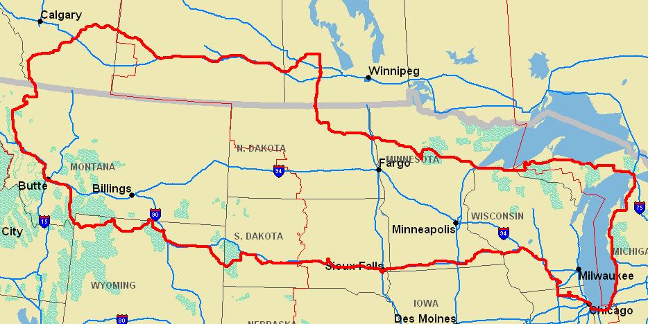
Our general route through the
woods and plains is in red. |
Hardly a mile of
this route was planned, although I
did just purchase passports
and wanted to get "my money's worth."
My original plan was to
drive east to Nova Scotia, but on a fluke headed west. So west I
went, and went, and went. When the car began falling apart in
Alberta, I started back toward home. Time and miles flew by so I
was shocked to find that I was way overdue for an oil change
when I got home. The complete loop was about 5000 miles. It's
funny we drove to Michigan and just stopped by the Rockies on
the way home. |
Part 1:
Exploring
Michigan's Upper and Lower Peninsulas... again.
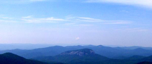
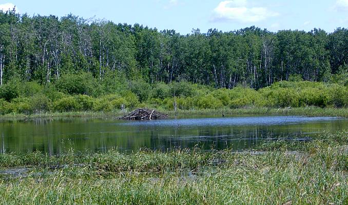
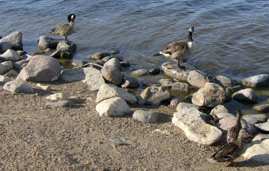
The great dune at Warren Dunes SP, MI. I love this beach. We wanted to camp here, but it was booked so we went north. I broke out the big tent at Hoffmaster SP, MI, my home for the next two days. It was in a suburban area. We had fun with friends making smores. We went to the beach, but it was too cold. So we explored Hoffmaster dunes before returning for a swim. When he wasn't wooing the children to sleep (they were excited), Israel and I pretended to be fire experts. Andrew wants you to have a bite of his camp breakfast at Hoffmaster. Israel and Glory left us to our own devices after breakfast. So we drove north, through urban Muskegan. This is the city beach and lighthouse. A decorated ship from WW2 was docked in Muskegan's busy harbor. We spotted a few funny sites along the way like the Mesick Pharamacy, next to the Bucksnort Cafe in Mesick, MI. After a long drive along the Traverse Bay, we stopped for a bite to eat at Michigan's favorite diner and was Andrew ever excited to see the Big Boy! I loved our campsite near St. Ignace at Straits SP. We had a perfect view of the Mackinac Bridge and clear, cool night. The Mackinac Bridge day and night at St. Ignace, the burial place of Pere Marquette. We stopped on one of the Lake Michigan beaches beside scenic U.S. 2. It was lonely and quiet and wonderful to be with my boy in his element. The water here is clear and cold. Perfect for a summer afternoon. The beach was pretty wild and frequented by large flocks of ring-billed gulls. Andrew liked to run up to the water with fistfuls of sand and drop them into the waves, running away as the cold water hit his feet. One of my favorite places on earth is the Seney National Wildlife Refuge. A road meanders through miles of northern wetlands. I was happy to revisit. Seney is home to countless birds like these Canada Geese, who held me up as they crossed the road. A beaver, one of many we saw on this trip, builds his dam in one of the lagoons at Seney. Seney is also home to a large number of trumpeter swans. We camped that night in mosquito-infested woods near Christmas, Michigan: home of gangster Santa. Lake Superior is lined with these smooth rocks all the way around. This is the lake as viewed from Bay Furnace at dusk. The campground at Bay Furnace in Hiawatha National Forest was ablaze with orange flowers. Our camp at Bay Furnace was pretty sparse and surrounded by thick woods. It rained and drizzled all night. From outside Munising you can peer down Lake Superior at Grand Island. One of the most beautiful beaches, Au Train Beach on Lake Superior. A view of Agate Falls near Bruce Crossing, MI. We stopped to change a diaper and were surprised to see a path to some rapids and then these falls. A rusting rail bridge above Agate Falls harkens back to the U.P.'s days as a major copper mining area. A favorite place for me is Union River Beach at the east entrance to the Porcupine Mountains Wilderness. Andrew and I dipped our feet in the freezing Lake Superior water that laps up against the Porkies. Andrew and Daddy on a a piece of Superior driftwood. As the night wore on, we left Michigan, dirving through the Apostle Islands region of Wisconsin.

The great dune at Warren Dunes SP, MI. I love this beach. We wanted to camp here, but it was booked so we went north.
|
|
Part 2:
Fields and forests of
Minnesota, North Dakota, & Manitoba
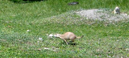
After spending the night in a cheap, shady motel in Duluth, we were pleased to find more pastral settings like this west of the city. After miles and miles of woods and fields, we stopped for a rest at Cass Lake, where I met this cold dragonfly. Cass Lake was weedy and cold and gray and there were warnings posted about swimmer's itch so we stayed out. Impressions of Northwoods flora, taken in Minnesota. Jessica and Andrew pose for us at Bemidji's pride and joy: the giant Paul Bunyan statue. Here he looks out over the edge of the vast Northwoods from Bemidji. West of the city the woods gave way to the prairie. The mighty Mississippi, a few miles from its point of origin southwest of Bemidji. This is the spot where the Mississippi begins its journey to the Gulf of Mexico. Fitting that crowds gather to see our friend on his way. I cross the Mississippi by foot in lake Itasca State Park, where the Northwoods meet the prairie. After a night's rest in Grand Forks, where we saw the Blue Angels practicing, we arrived in an island of North Dakota wilderness: Sulleys Hill. A prairie dog in mid-flight at Sulleys Hill. The preserve hsoted a moderately sized dog city. Sulleys Hill was made a national park by Teddy Roosevelt, but now operates as a game preserve. The area adjoins the Spirit Lake Indian Reservation. The town of Rugby, North Dakota, thinks it is the hub or center of North America*. * If you don't count six countries and the Caribbean. After crossing the Turtle Mountains at the Manitoba/ND border we passed a huge turtle in Boissevan, MB. A wildlife museum in Boissevan. Don't order "American cheese" at this Subway in Wasagaming. In Canada, they call it "white cheese." We drove through Riding Mountain National Park because we heard it was home to some big moose. The park is the last stand for the Northwoods west. We took a night drive to see animals. Here is Clear Lake in Riding Mountain NP at sunset. Notice the swarm of flies? Creepy, lonely Grayling Lake reminded me that Riding Mountain has one of the densest bear populations in the world. Riding Mountain has a huge campground with plenty of room for everyone. Notice the bear warning on the picnic table... Andrew finds a big, scary animal got into his tent! Andrew is usually the first one to wake up and demand breakfast when we go camping. Andrew found a squirrel. Do you see it? We drove through the birch forest on a gravel road, listening to comedy on the CBC. It was a good couple hours. Suddenly, we saw two charging bison bulls using the road ahead of us. The bison were in rut, which made for some odd behavior. Andrew checks out the bear-proof garbage cans and wonders, "Are these Andrew-proof?" The bison herd at Lake Audy in Riding Mountain National Park. We were officially in the West now. Grass surrounds Lake Audy and its quiet, bear-infested campground. We just drove through but stopped to take it in. As we left Riding Mountain, we spotted a huge beaver dam and wood duck in this pond. A bit further up the road was a handsome black bear in our path.

After spending the night in a cheap, shady motel in Duluth, we were pleased to find more pastral settings like this west of the city.
Part 3:
The
Canadian Plains are more
exciting than they look...
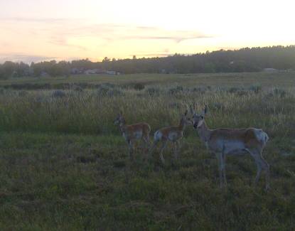
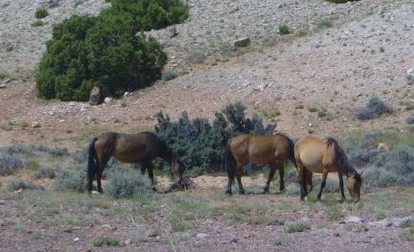
Outside of Riding Mountain, the scenery changes quickly. We are in Manitoba's Canola country. The yellow Manitoba Canola fields were separated by tiny towns, many surrounding small Ukrainian churches. Andrew let out a lot of steam at the Saskatchewan Welcome Center on the Trans-Canada Highway. Andrew playing hide-and-go-seek in Saskatchewan. What Saskatchewan's residents find natural is cheering on their favoUrite football team, the Rough Riders. What else to do in all this grass? After hours of driving through Canola, we came across an oasis in the handsome capital city, Regina. This is where the Canadian Mounted Police train. Being Yankees in a Anglo-phile town made us nervous, but we paused for a family shot in Regina. The Georgian dome of the Capitol Building in Regina peers over a lush garden, a street festival, and a teeny skyline. Andrew and I enjoy the geese along the Wascanas River in downtown Regina. Near Chaplin, SK, the plains were covered in salt piled next to brakish ponds. Plovers patrolled the edges. A strange place to see seabirds. Sunset near Herbert, Saskatchewan. This is what most of the province looked like along TC-1. Every Saskatchewan town has its own grain elevator, probably filled with Canola. A herd of pronghorn patrol fields near the middle of nowhere, otherwise known as Sceptre, SK. South of Sceptre, we reached our goal for the day: the elusive Sand Hills of Saskatchewan. The Sand Hills were a few miles apart and huge. This one was on a ranch along ten miles of prickly gravel road. The hills were very hot under the Plains sun and teeny, tiny white bones or shells were mixed in with the fine sand. The Canola fields were replaced by ranches in western Saskatchewan. This one is east of Liebenthal. Horses pause from grazing the ranch to see what in the world Chicagoans are doing in so remote a place. Across the border in Alberta, we found some real hints of the West at the badlands surrounding the Saskatchewan River. The Red Deer River has also cut into the Plains to create eerie, badlands like this. As north as I have ever been, Andrew suffered a severe diaper blowout. We stopped and changed him alongside the road. Notice the trunk is broke? Andrew at Dinosaur Provincial Park in Alberta, where we made ourselves an early camp. The car was falling apart and I gave up plans of going further. The badlands at Dinosaur PP are a treasure trove of fossils. Many lay where discovered under little houses. A view of Dinosaur PP. I love camping in badlands like these, even though this one recently underwent a serious flash flood. An oasis in the badlands at Dinosaur Park. A pioneer's cabin was recontructed in the park. He built it from stolen lumber he pulled out of the Red Deer River. The badlands were populated by sharp mule deer like this lady here. A bird's eye view of the park: photos do not do justcie to the massive scale here. If you squint, you can see farms on the horizon. The Red Deer River of Alberta at Dinosaur Park, where we met some pretty strange locals. Because of recent flooding, we could see deer tracks in the mud around our campsite in the morning. A high water creek cuts through the campground in Dinosaur Park. I crossed this creek twice with dirty laundry. Our campsite at Dinosaur Provincial Park. Andrew made quite a mess in the mud. Alberta seems to love its snakes. If I saw one, I would speed up to make sure I killed it. A very British town in the Old American West, Fort McLeod. Canola fields bid us goodbye as the Canadian Rockies rise out of the horizon to the southwest, drawing us in.

Outside of Riding Mountain, the scenery changes quickly. We are in Manitoba's Canola country.
Part 4: Rocky Mountain
Madness: from Waterton to Yellowstone
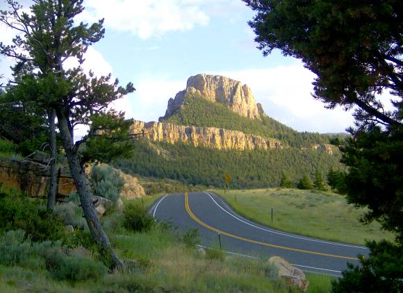
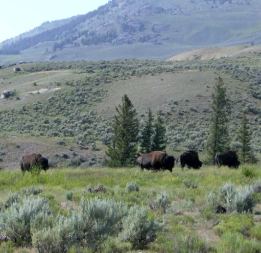
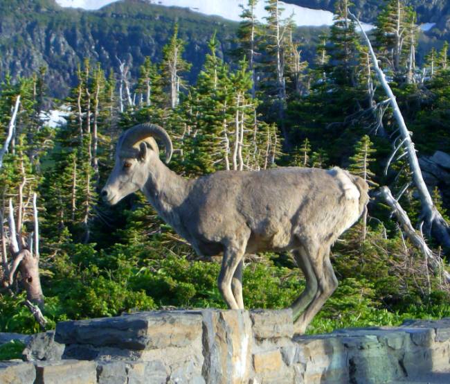
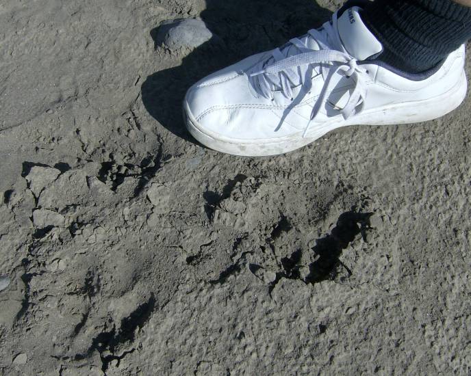
This photo album is like looking at heaven so hold on tight. Here is Waterton National Park in Alberta behind barbed wire. Fields around Waterton were filled with flowers (and prairie dogs.) Near the Waterton bison herd's watering hole. A perfect shot of the front range Rockies at Waterton. On the road to Montana. This was shot a few miles from the U.S. customs checkpoint, where it pained me to open my broken trunk. This is what happens to the glaciers of Glacier National Park. This was taken near Babb, Montana. St. Mary Lake in Glacier National Park. Not far from here we spotted a strange chestnut colored bear hurrying across the road. Away from the yuppies and suburban tourists are quiet mountain scenes like this. The Northwoods bump into the peaks at Glacier. Notice the snow packs in high summer. Another shot taken on the Going to the Sun Road that cuts through the park. At Logan Pass (el. 7000 ft.), bighorn sheep and mule deer sip on pools of antifreeze along the road. This is why we were able to get shots of the elusive bighorn. Snow adorns this peak near Logan Pass. Water falls are everywhere in Glacier Park in the summer. Our third bear of the trip was this digging black bear in Glacier National Park. The bear was very close to the road and causing quite a commotion. Another waterfall in Glacier National Park. Rapids along a Glacier creek that was situated on a dirt road off the main highway. Watch out for bears if you want to fish Glacier's trout streams. An island in beautiful Flathead Lake. We slept in Kalispel and drove along this lake for several miles before finding the highway home. Inside a reconstructed teepee set up in Grant-Kohrs NHP. This is probably the sort that the Flatheads and Blackfeet built in the Plains. Lazy longhorn wait things out on the old Grant-Kohrs ranch in Montana. Back up the mountains, we came across fields of color again. Andrew is a natural in the woods by now. Our camp near Quake Lake in the Gallatin National Forest should have been a pleasant place to spend a night. Quake Lake was formed in 1959 when the earth shook and split open causing landslides that dammed up a stream and drowned a forest (and some campers.) We ate dinner near West Yellowstone. Here is Jess and Andrew near the Madison River. Off to bed after dinner and we were reminded of the danger in camping in the northern Rockies. The sign in inset was screwed to our picnic table. At night I heard a heavy animal and thought the worst. I scared it off with my car keys. Here I am thankful it is morning and we are alive. A little pond covered in water plants on a mountainside in Gallatin NF. Driving through the Quake Lake area near our campground in the forest. Yellowstone was very busy. I sat in this jam for about an hour and about three more were on the way. Remnants of a ten-year old wildfire in Yellowstone. Posing for a shot in Yellowstone National Park. No one ever takes photos of ducks and ponds in Yellowstone... so we did. A dangerous bull elk resting his eyes in the brush in Yellowstone. A bison herd in Yellowstone. Yellowstone's famous waterfalls were a thunderous sight. Andrew always wants to pretend he's driving on the road. See the video for more of this sort of thing. The Canyons area of Yellowstone National Park. Volcanic formations called needles reminded us that Yellowstone is simply a huge volcano bursting at the seams. I wanted to see the Lamar Valley since it is home to the biggest, baddest wolf packs in America. Here is their food: bison. Lamar is beautiful, but is also a place of death and danger. Here are huge bison bones in the valley. A Lamar Valley bull surveys the situation. We found a set of wolf prints around a watering hole in the Lamar Valley. A stream makes for a busy place bustling with tourists, pronghorn, bison, etc. The water also seems to attact the birds whose prints we saw along its edge. A view of the Lamar Valley as we exit Yellowstone Park. Before we left the park, we were treated to this black bear munching grass a few hundred feet away. The road leads down and out of Yellowstone toward Cody, Wyoming, a town that is in love with itself.

This photo album is like looking at heaven so hold on tight. Here is Waterton National Park in Alberta behind barbed wire.
Part 5:
The high road back east
| Click below to
see 360 view! |
 |
Coming soon. |
360s coming soon.
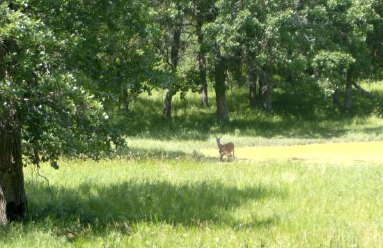
Outside Yellowstone on Hwy 14A we started east on a one-way course toward Chicago. We made amazing time considering the obstacles. Deep in Shoshone country stood a monument to the cowboys and Indians of Wyoming. Red rock near Cody, Wyoming, at sunset. Tha tnight we stayed in the motel Jessica entitled the "Worst Western" in Lovell. Storms brew above the Wyoming wilderness. Wild horses grazing the desert scrub in Bighorn mountain NRA. The land along the Bighorn River was striking in its desert beauty. Andrew at Bighorn Canyon on the wyoming/Montana border. The green Bighorn River creeps throug the wild desert canyon. Another view from above of the Bighorn River. A desert mount stand tall above the Montana scrub and willows. A band of beautiful, wild horses in Bighorn NRA, Wyoming. Red rock in the Bighorn Mountains. As we drove up the Bighorn Mountains to unheard of heights we found many free-range cattle. The tip, top of the Bighorn Mountains, near the mysterious Medicine Wheel at almost 10000 feet. Around here it is hard to breath. Alpine flora in the Bighorn Mountains. Believe it or not, this IS the way home. I made a snowball in July. Others were sledding without sleds. Looking down the lush side of the Bighorn Mountains on the free range. Below the mountains we came across this old marker for the famed Bozeman Trail of cowboy lore. We stopped for a bite in the beef town of Sheridan. The view from our tent at laid-back Keyhole SP, near the Black Hills, in eastern Wyoming. As sun was setting we spotted these nearby pronghorn in Keyhole's prairie. A mule deer spotted in Pine Haven, Wyoming. Our Keyhole camp in the morning. The area was frequented by local fishermen. The Crazy Horse Monument in the Black Hills is a complete waste of time and a major rip-off. Perhaps, this is the old chief's last revenge on us. Wild, creepy eyes goats in a campground in Custer State Park in the heart of the South Dakota Black Hills. Custer's bison herd is well-known. This afternoon they were lazing along the trees. During the rut, it is wise to keep an eye on bulls. At Wall Drug Andrew gropes a fiberglass hooker. What else can I say? Andrew appreciating the awesomeness of Wall Drug. Andrew at age one. I already have this photo on another page in the diaries, taken one year before. Badlands National Park: the sky was overcast bringing out the shades of pink and green in the landscape. Stop and admire Badlands National Park. I cannot drive past it myself. The badlands cut into the South Dakota short-grass prairie here. Here is where you can pay a guy to feed some prairie dogs near Interior, SD. We slept that night in the friendly, hospitable town of Mitchell. It was our second time here, but Andrew's first. Mitchell's Corn Palace is the place to be. Each year it is decorated with corn cobs and husks in a different theme. Andrew and I beneath the legs of the Jolly Green Giant in Blue Earth, Minnesota. Andrew was really playing around here. I was glad and hoped he would sleep the whole way home through Wisconsin. I did not pose him for this. He is just ready for business.

Outside Yellowstone on Hwy 14A we started east on a one-way course toward Chicago. We made amazing time considering the obstacles.
|


, Israel and I pretended to be fire experts.")


")


, bighorn sheep and mule deer sip on pools of antifreeze along the road.")


")


