UT Trip Stats (12/07):
Counties visited:
1
Last visited:
8/2007
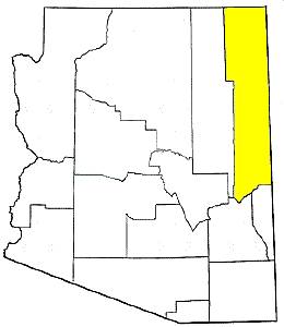
Best county:
Apache Co.
Town visited most:
Chinle
Most impressive town:
Chinle
Least impressive town:
Teec Nos Pos
Biggest town:
Chinle
Most scenic area:
scrub forest along AZ-264 west of Window Rock.
Three words:
hot, punishing, Navajo
State Animal:
stray goats
Road Trips:
Ring of Fire (8/2007)
Neighboring States:
CA, NM,
UT,
NV,
SON
People:
The people of the northeast are either Navajo or white baby boomer fans
of Native America. Nobody I met seemed to be rolling in money. The
Navajo I met with in Chinle were friendly and helpful. They were
generally non-confrontational and more reserved in nature than people
from other areas of the U.S. The Navajo Nation is a bilingual world.
Radio stations, signs, and printed matter may be serving those who speak
the Native language. This gives Arizona the feel of a foreign country.
|
 |
First Contact:
I first entered Arizona by foot while visiting the Navajo Nation's
Four Corners Monument. It is not a big deal, but is the most
entertaining thing in the middle of the vast Southwest desert in the
area. From here I visited a big gas station trying to be a tourist
trap. A few Navajo women outside the station sat in kitchen chairs,
roasting under the sun, swatting away a hoard of flies. As I
continued, the one hundred degree heat and the speeds began to take
their toll and, by the time I reached Chinle, my tire was about the
blow open. I tried to find a tire shop, but the closest one was 100
miles away in New Mexico. This would be the short end to my first
trip to Arizona. |
Apache Co. (8/2007)
Navajo
Nation. Most of the locations described are located
within the boundaries of the Navajo Nation. See the notes to the
left on people to learn more about my initial reactions to the
Navajo people.
Four Corners
Monument.
A small tribal park set atop a plateau overlooking the desert.
It is run cooperatively between the Navajo and Utes and marks
the only place in the U.S. where four state borders meet. The
marker is surrounded by the flags of each state and the tribal
nation. Busloads of people pay a few bucks to stand on top of
the marker and to shop in what was the most competitive and,
thus, well-priced Native American craft markets in the
Southwest. Craftsmen sit working in shady lean-tos seemingly
unaware that you are looking at their goods.
The monument is
worth a stop. Teec Nos Pos.
A Navajo town that consists of a gas station and Indian crafts
store. The air was full of flies and visible heat.
Chinle.
I almost busted a tire in Chinle, which is a small town to the
west of the Canyon de Chelly NM, an Anasazi historic site. The
town is the last place for nearly 75 miles to eat or fill up.
While I was changing my tires, I was being watched by a band of
curious, loose horses.
Red Mesa.
There are, in fact, red mesas here. Mexican Water.
There is not any water here, let alone that of the Mexican
variety. Rock Point. Round Rock. There is, in
fact, more than a few red rocks here. Many Farms.
I wouldn't say "many." Ganado. Here the desert
becomes a bit more green. Cross Canyon. The
area around here is a large and beautiful, well-spaced pine
forest. The road is busy with Navajo coming to and from Window
Rock to the east. St. Michaels. Window Rock.
A large town at the New Mexico border that is home to many
artists.
|
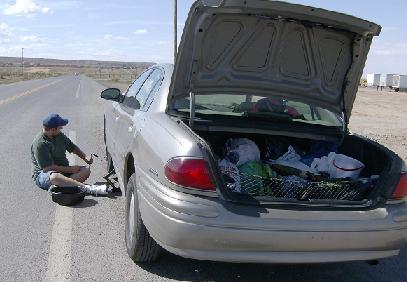
I learned a lesson about desert driving when a
heat nearing 100 degrees ripped apart my tires near Chinle.
A couple of horses watched me change the tire. (2007)

There are more than a few loose horses, goats,
sheep, and feral dogs in the deserts of Apache County.
(2007)
|
|
|